The first images from Cloudsat are in. They show the 3-D aspects of clouds instead of the flat satellite pictures shown on the weather channel.
"We're seeing the atmosphere as we've never seen it before," said Deborah Vane, CloudSat deputy principal investigator at NASA's Jet Propulsion Laboratory, Pasadena, Calif. "We're no longer looking at clouds like images on a flat piece of paper, but instead we're peering into the clouds and seeing their layered complexity."
The first-ever millimeter wavelength radar, CloudSat's Cloud-Profiling Radar is more than 1,000 times more sensitive than typical weather radar. It can observe clouds and precipitation in a way never before possible, distinguishing between cloud particles and precipitation. Its measurements are expected to offer new insights into how fresh water is created from water vapor and how much of this water falls to the surface as rain and snow.
CloudSat was launched April 28 from Vandenberg Air Force Base, Calif., along with NASA's Cloud-Aerosol Lidar and Infrared Pathfinder Satellite Observations satellite. Both satellites will orbit 705 kilometers (438 miles) above Earth aboard NASA's "A-Train" constellation of five Earth Observing System satellites. The A-Train satellites will work together to provide new insights into the global distribution and evolution of clouds to improve weather forecasting and climate prediction.
CloudSat is managed by JPL, which developed the radar instrument with hardware contributions from the Canadian Space Agency. Colorado State University provides scientific leadership and science data processing and distribution. Ball Aerospace and Technologies Corp., Boulder, Colo., designed and built the spacecraft. The U.S. Air Force and U.S. Department of Energy contributed resources. U.S. and international universities and research centers support the mission science team.
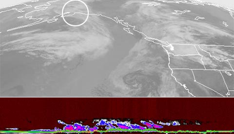
The flat image is on top (circled) while the bottom image is the 3-D of the same cloud formation here.
No comments:
Post a Comment